

Massive, fast moving structure seen beneath Tibetan Plateau in earthquake simulation study
A towering rock structure deep under East Asia has been indicated in research work involving 3-D supercomputer simulations using data from 227 earthquakes that hit the region during 2007-2011.
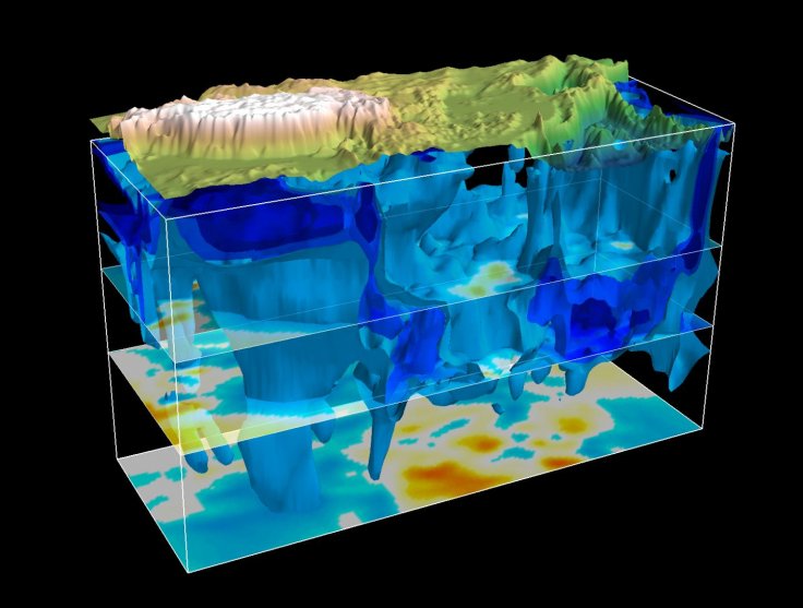
Three-dimensional high velocity structures beneath East Asia from 50 km to 1000 km depth viewed from the southeast. Surface topography with vertical exaggeration is superimposed for geographic references. Isosurfaces of high velocity anomalies in percent referenced to a one-dimensional earth model (STW105) at each depth are plotted from 1% to 4% with 1% interval. Three cut planes show shear wave velocity maps at 410 km, 660 km, and 1000 km depths. The highest elevations represent the Himalayas and the Tibetan Plateau.(Min Chen, Rice University)
It is expected to throw light on the fate of the subducted continental plates beneath the Tibetan Plateau. The formation of the Tibetan Plateau, known as ‘the roof of the world,’ which rises about 5km above sea level remains a puzzle.
The leading theory says it was formed and is maintained by the continuing northward motion of the India plate. But scientists can’t totally account for the speed of the movement of ground below the surface at the Tibetan Plateau.
What happened to the Tethys Ocean that once separated the India and Eurasia plates is also not known.
“We found that beneath the Tibetan plateau, the world’s largest and highest plateau, there is a sub-vertical high velocity structure that extends down to the bottom of the mantle transition zone,” lead author Min Chen from the department of Earth Sciences at Rice University says.
The bottom of the transition zone goes to depths of 660km.
“Three-dimensional geometry of the high velocity structure depicts the lithosphere beneath the plateau, which gives clues of the fate of the subducted oceanic and the continental parts of the Indian plate under the Eurasian plate,” Chen says.
A deep mantle upwelling beneath the Hangai Dome in Mongolia was also seen in the simulations.
Researchers from China, Canada, and the U.S. who worked together on the computer modelling published their results in the American Geophysical Union Journal of Geophysical Research, Solid Earth.
The technique
Earthquakes produce waves that can travel thousands of miles through the Earth. A seismic wave slows down or speeds up according to the rock composition and temperature. The scientists mapped these wave speed changes to model the physical properties of rock hidden below ground.
The team combined seismic records from thousands of stations for each earthquake to produce scientifically accurate, high-resolution 3-D tomographic images of the subsurface beneath immense geological formations up to depths of 900km.
They then matched the observed ground-shaking information at seismographic stations to fully numerical simulations run on supercomputers.
“What’s astonishing is how well those images correlate with what we know about the tectonics, in this case, of East Asia from surface observations,” co-author Jeroen Tromp, professor of Geosciences and Applied and Computational Mathematics at Princeton University says.
Chen and her colleagues ran simulations on the Stampede and Lonestar4 supercomputers of the Texas Advanced Computing Center through an allocation by XSEDE, the eXtreme Science and Engineering Discovery Environment funded by the National Science Foundation.
In all, the study used about eight million CPU hours on the Stampede and Lonestar4 supercomputers.
The collision of plates at the Tibetan Plateau has caused devastating earthquakes, such as the recent 2015 Nepal earthquake at the southern edge of where the two plates meet. Scientists hope to use earthquakes to model the substructure and better understand the origins of these earthquakes.
Besides a high velocity colossus beneath the Tibetan plateau and a deep mantle upwelling beneath the Hangai Dome in Mongolia, the work could potentially help find hidden hydrocarbon reserves underground.
Source: www.ibtimes.co.uk
comment 0